Connecticut GIS Day at Yale, Wednesday, November 15
https://csssi.yale.edu/gisday2017
Learn how to create, analyze, and share spatial data through web maps. The skills introduced in the workshop are beneficial for faculty and staff that want to learn a platform for analyzing spatial data and/or need interactive maps for use in classes, presentations, or websites. WesGIS Workshop WebMaps: How to analyze and share spatial data … Read more
a lecture by Chet Van Duzer
2-4 pm, Saturday, October 7
Fisk 208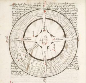
Want to help with relief efforts after this month’s earthquakes and hurricanes? WesGIS workshop: Crowdsourced Disaster Relief Mapping When: Friday, September 22, noon-1 pm Where: PAC 100 Who: Anyone in the Wesleyan community who is interested in helping out by tracing buildings from satellite images. No GIS/mapping experience required.
OSM Tasking Manager is a mapping tool designed and built for the Humanitarian OSM Team collaborative mapping. The purpose of the tool is to divide up a mapping job into smaller tasks that can be completed rapidly. It shows which areas need to be mapped and which areas need the mapping validated. Go the their … Read more
“Putting Human Geography on the Map” Workshop
September 28, 2017
U.S. Geological Survey, Reston, Virginia
The World-Wide Human Geography Data (WWHGD) Working Group is co-sponsored by the National Geospatial-Intelligence Agency and the U.S. Department of State. This free event will be held at the US Geological Survey (USGS) auditorium in Reston, Virginia.
WesGIS Workshop Story Maps: How to create a dynamic online map experience Friday, May 5, 1:30 pm PAC 100 Story maps combine interactive online maps with other content (text, photos, video, audio) to portray a place, event, issue, or pattern within a geographic context. Story maps can use the tools of a geographic information system … Read more