Skip to content Skip to content
Logo: Wesleyan University

WesGIS

Mapping and spatial data analysis at Wesleyan University

WesGIS
  • K Diver
    • Research
    • People
    • Teaching
    • cv
  • WesGIS
    • GIS Assistant Program
    • GIS teaching
    • GIS research
  • Newsfeed
  • Events
    • Workshops
    • Seminars
  • Gallery
    • Gallery
    • Student projects
    • Maps in the Media
  • Resources
    • Data sources
    • GIS blogs
    • Jobs & Internships
    • Training
    • Facilities
  • Equity

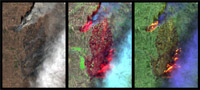
Frequently Updated Multi-Spectral Imagery Available through the ArcGIS Living Atlas of the World

June 21, 2018 by kdiver
Go to http://www.esri.com/esri-news/releases/18-2qtr/esri-announces-release-of-sentinel2-image-services to learn more.
Categories Data source
Post navigation
Job open at Stanford Geospatial Center
Kilauea 360 Imagery story map

Recent Posts

  • Software Engineer opening with Conservation Biology Institute
  • GIS Analyst job in MA
  • GIS specialist job with Terraformation (can work remotely)
  • GIS research associate job with Colorado State and NPS
  • GIS Analyst job at CT GIS Office

Categories

© 2022 Wesleyan University