The Geography Program at West Virginia University is currently recruiting graduate students for the 2018-19 academic year, with opportunities for funding though competitive University fellowships, research assistantships, and teaching assistantships.
kdiver
PhD opportunity at Clark Univ
The Agricultural Impacts Research Group at Clark University’s Graduate School of Geography is looking for PhD candidates interested in studying the drivers and impacts of tropical agricultural change
CT GIS job
A local Connecticut engineering firm has an opportunity for multiple GIS practitioners for a 6 month contract with the potential for permanent employment.
Hydrologist I position: geospatial modeling
Position at the St Johns River Water Management District, Northeast Florida
Graduate Assistantship in GIScience from University of Hawaiʻi at Mānoa
A Graduate Assistant position is available at the Department of Geography, at the University of Hawaiʻi – Mānoa for Aug 2017-May 2018.
Call for Applicants: NSF REU: GIS for Disaster Resilience Spatial Thinking, Summer 2018
The Center for Geographic Information Science & Technology at the Rochester Institute of Technology is now accepting applications for the National Science Foundation (NSF) Research Experience for Undergraduates (REU) Site ‘Geographic Information Systems (GIS) for Disaster Resilience Spatial Thinking’ summer 2018 cohort. Full applications (including reference letters) for the 2018 REU Cohort are due Friday 1 December 2017.
GIS Analyst I Position Available – LandVest – Boston
The Boston office of LandVest is seeking a GIS Analyst to work in our Real Estate Consulting Group. The job description is located at the following link: https://landvest.egnyte.com/dl/dj7nkuxob7. Please submit cover letter and resume to James DeNormandie at jdenormandie@landvest.com.
2016 Elevation Data on CT ECO
The 2016 flight elevation data access is nearly complete on CT ECO!
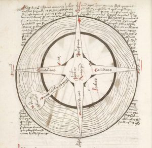
Apocalyptic Cartography: Thematic Maps and the End of the World in a Fifteenth-Century Manuscript
WesGIS workshop: Crowdsourced Disaster Relief Mapping
Want to help with relief efforts after this month’s earthquakes and hurricanes? WesGIS workshop: Crowdsourced Disaster Relief Mapping When: Friday, September 22, noon-1 pm Where: PAC 100 Who: Anyone in the Wesleyan community who is interested in helping out by tracing buildings from satellite images. No GIS/mapping experience required.


